OUR ROUTES
Please click on links for
GPX, OS maps, FKT’s & Route guides
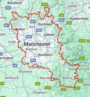
A 200 mile route that orbits Manchester in an anti-clockwise direction, has been created with the purpose of linking some classic, as well as plenty of lesser-known off-road riding spots this area offers.
Riding through Cheshire, Staffordshire, Derbyshire and Lancashire, the many highlights will include some of the best off-road biking trails found in the North West. Macclesfield Forest, the limestone trails of the White Peak including the mighty Cavedale, precedes Rushup Edge and Roych Clough that are part of the Dark Peak section before a substantial part of the arduous Pennine Bridleway. North of the city includes the ‘Three Towers’ section consisting of Holcombe, Darwen and Rivington moors, all preceded by a pair of purpose built MTB trails at Lee Quarry and Cragg Quarry.

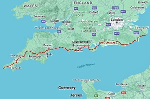
A 200 mile West Country route in a roughly figure-of-eight direction, has been created with the purpose of linking some classic, as well as plenty of lesser-known off-road riding spots pieced together by several local riders.
Riding through South Gloucestershire, Wiltshire, Somerset and Avon, the many highlights will include some of the best off-road biking trails found in this area. Lansdown Hill, singletrack trails at Erlestoke, Salisbury Plain, and the Wessex Ridgeway precede some great trails through the stunning Longleat Forest, before heading west to the awesome Mendip Hills. The route criss-crosses the Mendips all the way to the beach at Weston-super-Mare before turning east again to reach some classic trails on Crook Peak and some purpose built MTB trails at local’s favourite Rowberrow. The final section then heads north-east to Bristol via some great trails at Burrington Ham, Bourton Combe, Ashton Court and Leigh Woods before a scenic jaunt through Bristol Harbour and on to Bath.
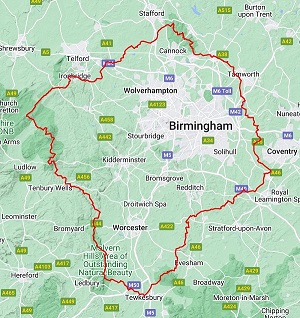
A 200 mile route that orbits Birmingham in a clockwise direction, has been created with the purpose of linking some great, and often lesser-known off-road riding spots this area offers.
Riding through Warwickshire, Worcestershire, Herefordshire, Shropshire and Staffordshire, the many highlights will include some of the best off-road biking trails found in the West Midlands. Bredon Hill, the Malverns and the two Clee Hills (Brown Clee is the highest point in Shropshire) are all in there, plus one of the premier riding destinations found in England, Cannock Chase, which is renowned for it’s natural and purpose built trails.
A 200 mile route that has been created with the purpose of linking the many fun descents this area offers..
There are incredibly over TWENTY FIVE significant downhill sections on this route which of course means a lot of uphill too!
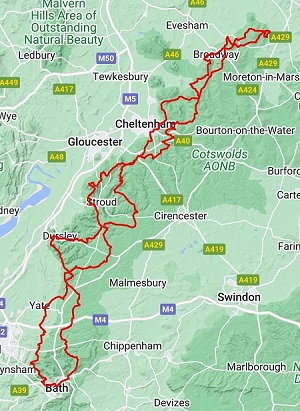
Starting in the city of Bath, the route heads north into the stunning Cotswolds AONB and covers the full length of the Cotswolds area there and back. This isn’t a regular ‘there n back’ route though – the return leg is on an entirely different route!
Riding through Somerset, Wiltshire, Gloucestershire, Worcestershire, Warwickshire and back again, the many highlights will include some of the best off-road biking trails found in England.
Not only is the riding superb, the views from the Cotswolds escarpment are fantastic too – especially looking west across the Severn valley towards the Black Mountains and the Malvern Hills.
The 100 mile version is basically the southern half of the 200 with an excellent link section.
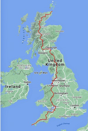
The ultimate UK mountain bike adventure and our flagship route! This is a 1,250 mile (2,000km) route with over 111,000ft (34,000m) of elevation gain, riding through England, Wales and Scotland.
LEJOG Off-Road features many of the best mountain bike area’s found in the UK. Some of the highlights include; Dartmoor, Exmoor, the Quantocks, the Mendips, the Black Mountains, the Long Mynd, the Cambrian Mountains, Forest of Bowland, the Yorkshire Dales, the North Pennines, the Scottish Borders and the Highlands. There’s also SEVEN trail centres encountered en route; Cardinham Woods (Cornwall), Ashton Court (Bristol), Hopton Woods & Eastridge Woods (both Shropshire), Coed Llandegla (North Wales), Newcastleton and Innerleithen (both 7 Stanes in the Scottish Borders).
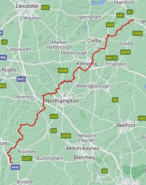
An 82 mile (132km) route with over 4,000 feet (1,220m) of elevation gain that starts at the south-western end of the county bordering Oxfordshire and heads north-east to traverse the whole length of this elongated county to finish just over the border in Cambridgeshire. Some of the highlights to be found are the large expanse of Pitsford Water, Geddington Chase and the historical Rockingham Forest area.
A coast to coast route across the most northerly and remotest part of England.
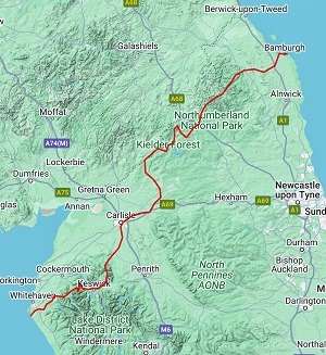
Starting on the Cumbrian coast, this 208 mile (335km) route with over 18,000 feet (5,490m) of elevation gain will cross the Northern Lake District, Kielder Forest Park and Northumberland National Park to finish on the stunning Northumberland coastline.
Some of the many highlights en-route are Lonscale Fell, Hadrian’s Wall, the paved Border Ridge and the Usway Burn in Upper Coquetdale.
There are also two superb trail centres on this route – Whinlatter Forest near Keswick and the remote Kielder Forest trails.
All in all, this makes for a true wilderness ride!
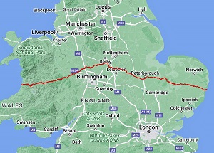
Starting at the well-known university town of Aberystwyth on the West Wales coast to the quintessentially English, old-fashioned seaside town of Southwold on the Suffolk coast. This is an unusual and interesting route spanning west to east across the central belt of the UK that takes in a contrast of landscapes from the wild Cambrian Mountains in Wales to the Fens in East Anglia and everything in between!
A 360 mile (580km) route with over 22,000 feet (6,700m) of elevation gain that will take you through Ceredigion, Powys, Shropshire, Staffordshire, Derbyshire, Leicestershire, Rutland, Northamptonshire, Cambridgeshire, Norfolk and finally Suffolk. Some of the many highlights include; the Cambrian Mountains, the Welsh Marches, the Long Mynd, the Ironbridge Gorge and the National Forest. Also en-route are three MTB trail centres at Nant-y-Arian near Aberystwyth, Cannock Chase and Thetford Forest.
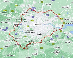
An anti-clockwise, orbital route around London by mountain bike. A journey of 200 miles (322km) with 10,000 feet (3,050m) of elevation gain that will take you through Hertfordshire, Buckinghamshire, Berkshire, Surrey, Kent and Essex. This route is easily accessible thanks to good rail links throughout, which means you can easily tackle a section of ‘The Smoke Ring’ as a day ride.
There are some great trail gems to be found on this route, while never straying too far from the metropolis. Some of the many highlights include Epping Forest, the Colne Valley, the Grand Union Canal, Swinley Forest MTB trails, the Surrey Hills, the North Downs, the Thames crossings and Thorndon Country Park in Essex.

The Solstice 100 (and 50) is MTB Epics’ local and well-established annual off-road event based at the popular Pomfret Arms pub close to the centre of Northampton. We are fast approaching it’s 10th edition and have used a different route every year, heading off in all directions of the compass. Some of the places visited on the routes include the Cotswolds, the Chilterns, Edge Hill, the Dassett Hills, the Greensand Ridge in Bedfordshire and the historic county of Rutland. Some of the towns and cities visited include Market Harborough, Buckingham, Thame, Princes Risbororough, Milton Keynes and Bedford. Up to and including 2023, we have created 13 routes totaling over 1000 miles!
From the rugged Atlantic coastline at Lands End to the white cliffs of Dover, this is a fantastic mountain bike adventure along the south coast of England. A 426 mile (686km) route with over 30,000 feet (9,150m) of elevation gain, riding through Cornwall, Devon, Dorset, Hampshire, the Isle of Wight, West and East Sussex and finally Kent.
As with all MTB Epics UK routes, ‘The Southern Way’ is all about a good variety of trails, places of interest and great scenery, there’s even FIVE boat trips including a HOVERCRAFT!
Some of the many riding highlights include; the Poldice Valley in central Cornwall, a full crossing of Dartmoor, Woodbury Common in Devon, the Purbeck Hills, the Isle of Wight and the South Downs. Also en-route are two MTB trail centres at Cardinham Woods near Bodmin and Haldon Forest near Exeter.